Tour of Tasmania: Mt. Wellington
Text-only version
Regional cities/towns
HOBART:
City centre
Eastern shore
Northern suburbs
Southern suburbs
Waterfront

DERWENT VALLEY:
Hamilton
Mt. Field National Park
New Norfolk

HUON VALLEY:
Cygnet
Geeveston
Huonville

KINGBOROUGH:
Bruny Island
Kingston
Taroona

Battery Point
Dover and Hastings
Mt. Wellington
Richmond
Salamanca Place
Wrest Point Casino

Tasmanian regions
Tasmanian flora & fauna
North-west coast
North and north-east
East coast
Tasman Peninsula
Southern Tasmania
West coast
Central and midlands
Site short-cuts
Introduction to Tasmania
Site map
About the Tour of Tasmania
Copyright and disclaimer
Provide feedback!
Tasmania FAQ
Tasmania Online
Search the Tour
Mt. Wellington (background of picture), rising to a height of 1271 metres, is a spectacular and panoramic backdrop for the city of Hobart. A short (22 km) drive from Hobart, the mountain has an observation and information centre on the summit. On a clear day it is possible to see parts of the state over 100 km away.

Movie Mt. Wellington overview, 2.55Mb QuickTime movie.

Movie Visiting Mt. Wellington, 1.92Mb QuickTime movie.

En route to the mountain is the historic Cascade brewery, which utilises the clear mountain streams in the manufacture of its product.

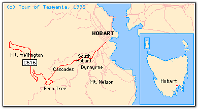
There are numerous walks of varying difficulties in the Wellington Park area. The road to the summit is fairly winding and is sometimes closed due to snow in the winter.

© 1995-2010
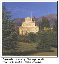